Making an iOS App
The Development of my Mapping Tool: Gaia

Over the past 6 months, I've been getting back into iOS development by creating Gaia, my generalist map consumption/navigation/outdoors app.
Why?
I decided to make Gaia /ˈɡaɪə/ guy-ah as there wasn't really an unopinionated app that allowed the consumption of XYZ tiles and offered some important features like offline caching, layering, and had the right mix of intuitive design and 'power features'. I wanted such an app to use while outdoors; in this scenario, Google/Apple Maps don't have nearly enough detail, and aren't very useful: I only really use them for transit and navigation, Street View, and discovering businesses.
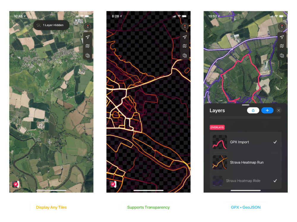
As I have written about before, one of the things I find most useful when off grid is confirming and correlating details from multiple sources. Sometimes details are ambiguous or missing on drawn maps, but visible on their aerial equivalents, or vice versa. It's also really useful to be able to have all the different maps I use in the same place, with the same controls and features, without having to switch between loads of apps. Layering data like Strava Heatmaps is also invaluable on the ground - in fact, the ability to do this was the main impetus behind Gaia.
I also wanted to learn more Swift (which - as an aside - is probably the most enjoyable programming language I've found so far).
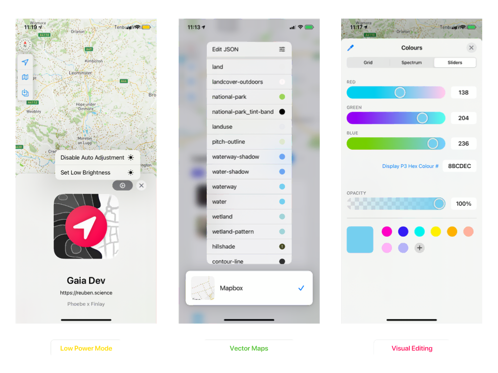
I wanted Gaia superficially to be easy to use, and visually pleasing, whilst underneath be very powerful, configurable, and extensible. I also wanted an app optimised for low power draw, and Gaia offers some really aggressive power saving features. I've managed to use Gaia for real world navigation on an iPhone 11 without charging for ~36 hours.
Mapbox
Under the hood, Gaia uses the Mapbox Maps SDK for iOS. Initially, I tried the builtin Mapkit library, but high resolution raster support was shit. Moving to Mapbox's offering provided much better support for complexities such as this, via the battle tested Mapbox Style Specification, and also means we don't have to recreate the wheel by creating another subpar rendering engine. Defined in JSON, it's a convenient way to define complex maps with both raster, and vector components, supporting geojson, embedded media - and in v10 - support for 3D terrain. Using the Style Specification, also provides portability, meaning the maps can be consumed cross platform outside Gaia, currently powering a skeleton desktop version.
{
"version": 8,
"sources": {
"demo_osm": {
"maxzoom": 20,
"tileSize": 128,
"tiles": [
"https://tile.openstreetmap.org/{z}/{x}/{y}.png"
],
"minzoom": 10,
"bounds": [
-8.82,
49.79,
1.92,
60.94
],
"type": "raster"
}
},
"layers": [
{
"type": "raster",
"id": "demo_osm",
"source": "demo_osm"
}
]
}
Gaia extends this with a higher-level concept of individual layers, which can be composed together by the user to create incredibly complex but consumable cartography.
{
"metadata": {
"id": "demo_osm",
"name": "OpenStreetMap Demo",
"group": "base",
"overrideUIMode": "dark"
"attribution": "© OpenStreetMap contributors"
},
"user": {
"groupIndex": 0,
"pinned": false,
"enabled": true,
"quickToggle": false
},
"style": {...}
}
'Visual' editing is supported for a wide range of options, but the JSON backing schemas are still exposed, if needed.
Although Gaia is using the Mapbox SDK, it's not based around Mapbox services, and doesn't by default interact with Mapbox at all. You can use them, but just as you can use any supplied raster/vector/geojson source.
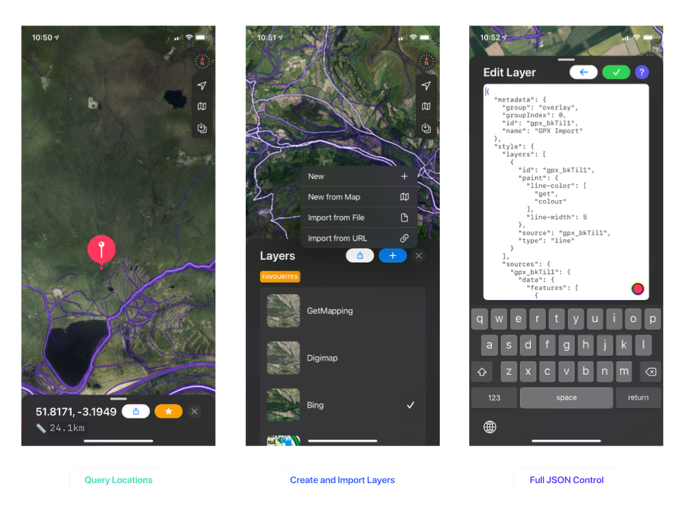
Currently, Gaia uses v6.3.0 of the Mapbox SDK, but I plan to upgrade to the maturing v10 over the summer. I also want to document the Layer Definition structure, and other 'power features' that Gaia uses, but the motivation isn't really there, as the app is for me, calibrated is against my own needs, and I'm not currently distributing it. It's also not idiot proof: you need some basic familiarity with the concepts that underpin digital maps, but you can import directly from XYZ tile/geojson/gpx URLs, which is fairly user friendly. It does however, warn on many common error conditions/counter intuitive states, and can ✨automagically✨ fix them.
Gaia is open source, available on GitHub, and can be compiled for your own devices, but isn't available in the App Store or anything.
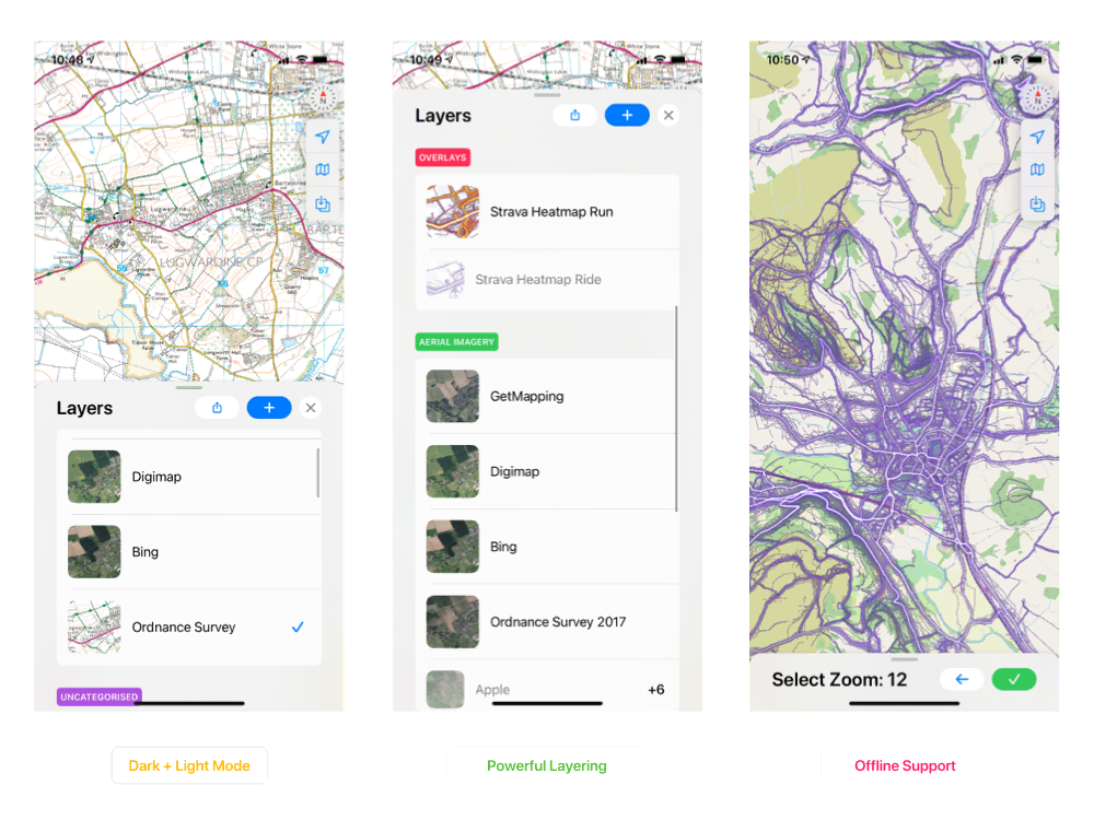
Features
- Full Mapbox Style Specification Support
- Multi-Layer Support
- raster
- vector
- geojson
- gpx
- Transparency Support
- On Device Editing
- Visual
- JSON
- Offline Maps
- Aggressive Low Power Mode
- Gesture Shortcuts
- Right/Left Hand Modes
- BNG Grid Reference Support
- Heading/Bearing Info
- Altitude Data
- Location Querying
- Adaptive Light/Dark Modes
- ...numerous others that I can't remember